

'%20fill='%23D9D9D9'/%3e%3c/mask%3e%3cg%20mask='url(%23mask0_515_7825)'%3e%3cpath%20d='M16.2473%207.47664C16.2473%206.85803%2016.2505%206.2979%2016.2473%205.74085C16.2442%205.26073%2015.905%204.86679%2015.4226%204.82371C14.9868%204.78678%2014.5448%204.82063%2014.106%204.79601C13.1536%204.74061%2012.2728%204.51287%2011.5133%203.90965C11.2021%203.66343%2010.8846%203.42646%2010.5703%203.1864C10.1812%202.88787%209.58675%202.97404%209.31908%203.26026C9.0483%203.54956%208.72461%203.78654%208.39781%204.00813C8.0212%204.2605%207.63215%204.49132%207.19018%204.59904C6.40585%204.78678%205.60907%204.85141%204.80295%204.80524C4.2147%204.77139%203.75718%205.18379%203.75407%205.76547C3.75095%206.31021%203.75718%206.85803%203.75095%207.40585C3.74162%208.66153%203.79764%209.91106%204.0622%2011.1421C4.39211%2012.6686%204.97725%2014.0782%206.00746%2015.2785C6.9692%2016.3987%208.15192%2017.1897%209.59298%2017.5836C9.82018%2017.6452%2010.0474%2017.6637%2010.2808%2017.6052C11.8121%2017.2143%2013.0571%2016.3834%2014.0562%2015.1861C15.2514%2013.755%2015.8303%2012.0685%2016.0917%2010.2588C16.2318%209.31707%2016.2598%208.36608%2016.2473%207.47664ZM13.7792%208.34454C13.1972%208.89851%2012.6183%209.45557%2012.0362%2010.0095C11.3173%2010.6959%2010.6014%2011.3822%209.88243%2012.0716C9.8233%2012.127%209.76727%2012.1885%209.71436%2012.2501C9.47471%2012.5271%209.04519%2012.5394%208.79308%2012.2716C8.35734%2011.81%207.87803%2011.3853%207.42362%2010.939C7.1435%2010.6651%206.85716%2010.4004%206.57704%2010.1265C6.40274%209.95722%206.34983%209.7541%206.44009%209.52328C6.52413%209.31092%206.73577%209.17858%207.00033%209.1755C7.16529%209.16935%207.31157%209.24936%207.4454%209.37863C8.00564%209.91721%208.5721%2010.4527%209.12611%2010.9944C9.21637%2011.0806%209.25995%2011.0867%209.35332%2010.9975C10.5329%209.86182%2011.7188%208.73232%2012.8984%207.59975C13.0633%207.43971%2013.247%207.3443%2013.4835%207.39354C13.7045%207.43663%2013.8632%207.56281%2013.9286%207.77517C14.0033%207.99061%2013.9473%208.1845%2013.7792%208.34454Z'%20fill='%23147029'/%3e%3c/g%3e%3c/svg%3e)
Verifed
3.94

Rating
51.57 MB
Download Size
About App
'%20fill='%23474747'/%3e%3c/mask%3e%3cg%20mask='url(%23mask0_515_7732)'%3e%3cpath%20d='M9.10508%2011.8396L15.0169%205.7847C15.218%205.57875%2015.4526%205.47921%2015.7207%205.48607C15.9888%205.49294%2016.2234%205.59935%2016.4245%205.8053C16.6256%206.01124%2016.7261%206.25152%2016.7261%206.52612C16.7261%206.80072%2016.6256%207.04099%2016.4245%207.24694L10.2513%2013.5902C10.0904%2013.755%209.90941%2013.8785%209.70833%2013.9609C9.50724%2014.0433%209.30616%2014.0845%209.10508%2014.0845C8.90399%2014.0845%208.70291%2014.0433%208.50183%2013.9609C8.30074%2013.8785%208.11977%2013.755%207.9589%2013.5902L1.76553%207.24694C1.56444%207.04099%201.46725%206.79729%201.47396%206.51582C1.48066%206.23436%201.58455%205.99065%201.78564%205.7847C1.98672%205.57875%202.22132%205.47578%202.48943%205.47578C2.75754%205.47578%202.99214%205.57875%203.19322%205.7847L9.10508%2011.8396Z'%20fill='%23474747'/%3e%3c/g%3e%3c/svg%3e)
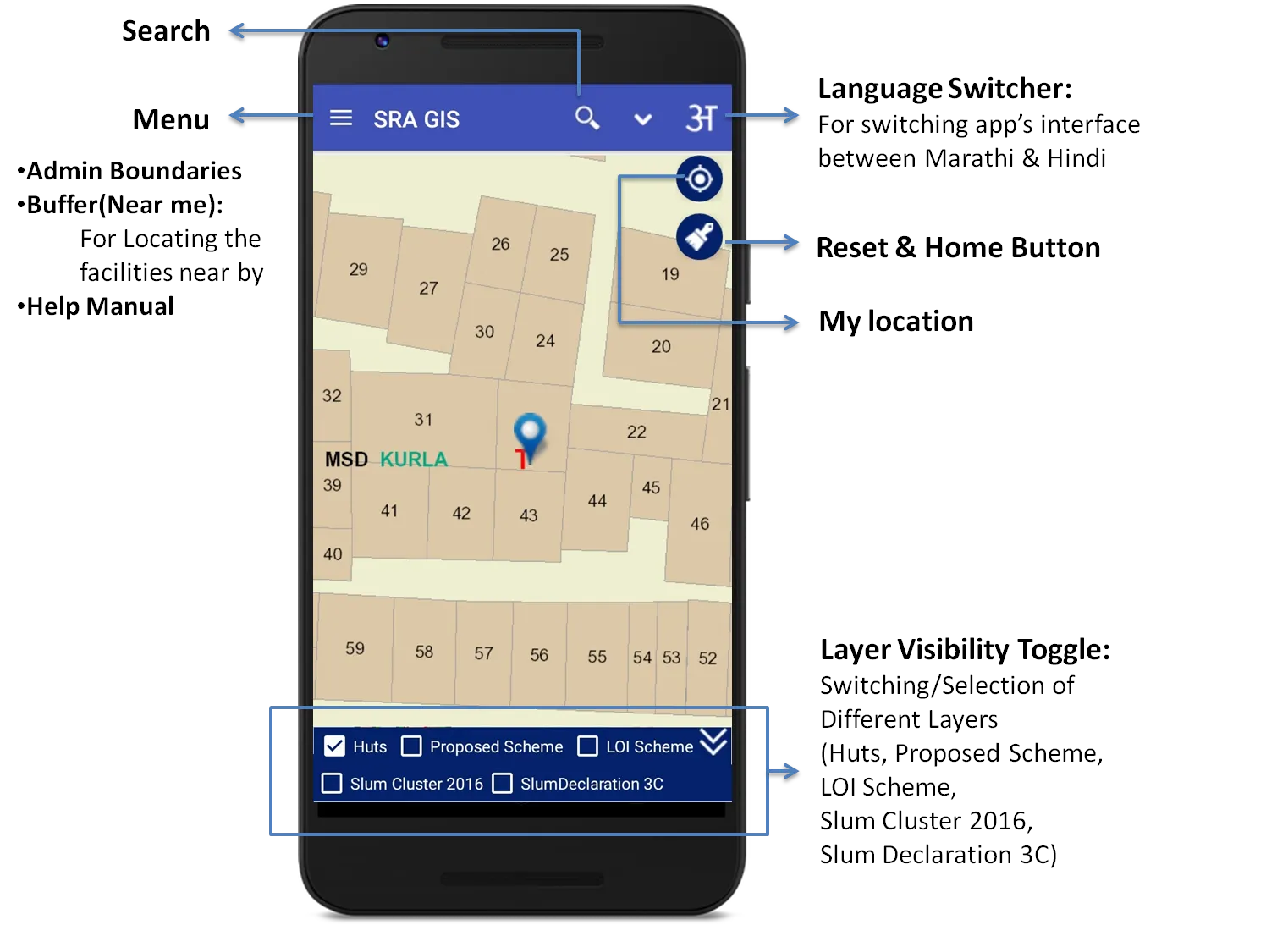
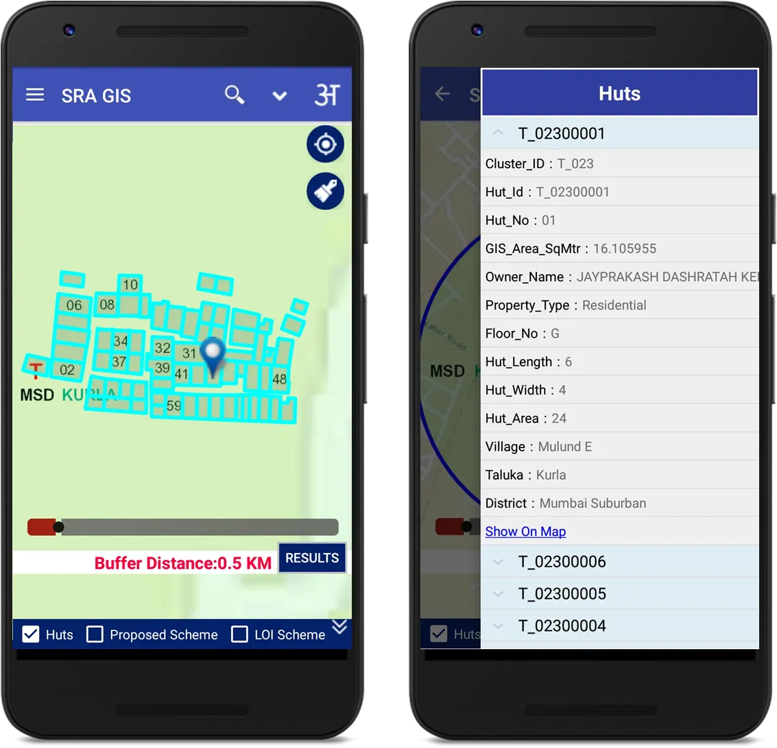
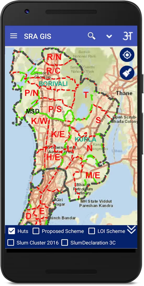
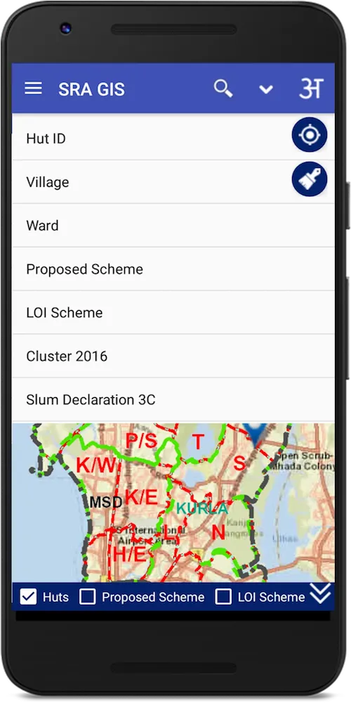
To provide citizen centric information of SR schemes on mobile,based on user location where GIS data for slums spread over entire Mumbai Municipal Corporation area has
been created.This encompasses layers containing boundaries of District,Taluka, Ward,Village,Slum Cluster,SR Schemes, Huts,etc.This GIS Mobile App is developed with the support of Utility Mapping Division of NIC,New Delh
been created.This encompasses layers containing boundaries of District,Taluka, Ward,Village,Slum Cluster,SR Schemes, Huts,etc.This GIS Mobile App is developed with the support of Utility Mapping Division of NIC,New Delh


'%3e%3cellipse%20cx='28'%20cy='24'%20rx='24'%20ry='24'%20fill='white'%20fill-opacity='0.9'%20shape-rendering='crispEdges'/%3e%3c/g%3e%3cmask%20id='mask0_142_4888'%20style='mask-type:alpha'%20maskUnits='userSpaceOnUse'%20x='20'%20y='16'%20width='16'%20height='16'%3e%3crect%20x='20'%20y='16'%20width='16'%20height='16'%20fill='%23474747'/%3e%3c/mask%3e%3cg%20mask='url(%23mask0_142_4888)'%3e%3cpath%20d='M25.4759%2024.0931L30.858%2029.3481C31.0411%2029.5268%2031.1296%2029.7353%2031.1235%2029.9737C31.1174%2030.212%2031.0228%2030.4205%2030.8397%2030.5992C30.6567%2030.778%2030.4431%2030.8674%2030.199%2030.8674C29.9549%2030.8674%2029.7413%2030.778%2029.5583%2030.5992L23.9198%2025.1119C23.7734%2024.9689%2023.6635%2024.808%2023.5903%2024.6293C23.5171%2024.4506%2023.4805%2024.2718%2023.4805%2024.0931C23.4805%2023.9143%2023.5171%2023.7356%2023.5903%2023.5569C23.6635%2023.3781%2023.7734%2023.2172%2023.9198%2023.0743L29.5583%2017.569C29.7413%2017.3903%2029.958%2017.3039%2030.2082%2017.3099C30.4583%2017.3158%2030.675%2017.4082%2030.858%2017.5869C31.0411%2017.7656%2031.1326%2017.9742%2031.1326%2018.2125C31.1326%2018.4508%2031.0411%2018.6594%2030.858%2018.8381L25.4759%2024.0931Z'%20fill='%23474747'/%3e%3c/g%3e%3cdefs%3e%3cfilter%20id='filter0_d_142_4888'%20x='0'%20y='0'%20width='56'%20height='56'%20filterUnits='userSpaceOnUse'%20color-interpolation-filters='sRGB'%3e%3cfeFlood%20flood-opacity='0'%20result='BackgroundImageFix'/%3e%3cfeColorMatrix%20in='SourceAlpha'%20type='matrix'%20values='0%200%200%200%200%200%200%200%200%200%200%200%200%200%200%200%200%200%20127%200'%20result='hardAlpha'/%3e%3cfeOffset%20dy='4'/%3e%3cfeGaussianBlur%20stdDeviation='2'/%3e%3cfeComposite%20in2='hardAlpha'%20operator='out'/%3e%3cfeColorMatrix%20type='matrix'%20values='0%200%200%200%200%200%200%200%200%200%200%200%200%200%200%200%200%200%200.25%200'/%3e%3cfeBlend%20mode='normal'%20in2='BackgroundImageFix'%20result='effect1_dropShadow_142_4888'/%3e%3cfeBlend%20mode='normal'%20in='SourceGraphic'%20in2='effect1_dropShadow_142_4888'%20result='shape'/%3e%3c/filter%3e%3c/defs%3e%3c/svg%3e)
'%3e%3cellipse%20cx='28'%20cy='24'%20rx='24'%20ry='24'%20transform='rotate(-180%2028%2024)'%20fill='white'%20fill-opacity='0.9'%20shape-rendering='crispEdges'/%3e%3c/g%3e%3cmask%20id='mask0_142_4982'%20style='mask-type:alpha'%20maskUnits='userSpaceOnUse'%20x='20'%20y='16'%20width='16'%20height='16'%3e%3crect%20x='36'%20y='32'%20width='16'%20height='16'%20transform='rotate(-180%2036%2032)'%20fill='%23474747'/%3e%3c/mask%3e%3cg%20mask='url(%23mask0_142_4982)'%3e%3cpath%20d='M30.5241%2023.9069L25.142%2018.6519C24.9589%2018.4732%2024.8704%2018.2647%2024.8765%2018.0264C24.8826%2017.788%2024.9772%2017.5795%2025.1603%2017.4008C25.3433%2017.222%2025.5569%2017.1326%2025.801%2017.1326C26.0451%2017.1326%2026.2587%2017.222%2026.4417%2017.4008L32.0802%2022.8881C32.2266%2023.0311%2032.3365%2023.192%2032.4097%2023.3707C32.4829%2023.5494%2032.5195%2023.7282%2032.5195%2023.9069C32.5195%2024.0857%2032.4829%2024.2644%2032.4097%2024.4431C32.3365%2024.6219%2032.2266%2024.7828%2032.0802%2024.9257L26.4417%2030.431C26.2587%2030.6097%2026.042%2030.6961%2025.7918%2030.6901C25.5417%2030.6842%2025.325%2030.5918%2025.142%2030.4131C24.9589%2030.2344%2024.8674%2030.0258%2024.8674%2029.7875C24.8674%2029.5492%2024.9589%2029.3406%2025.142%2029.1619L30.5241%2023.9069Z'%20fill='%23474747'/%3e%3c/g%3e%3cdefs%3e%3cfilter%20id='filter0_d_142_4982'%20x='0'%20y='0'%20width='56'%20height='56'%20filterUnits='userSpaceOnUse'%20color-interpolation-filters='sRGB'%3e%3cfeFlood%20flood-opacity='0'%20result='BackgroundImageFix'/%3e%3cfeColorMatrix%20in='SourceAlpha'%20type='matrix'%20values='0%200%200%200%200%200%200%200%200%200%200%200%200%200%200%200%200%200%20127%200'%20result='hardAlpha'/%3e%3cfeOffset%20dy='4'/%3e%3cfeGaussianBlur%20stdDeviation='2'/%3e%3cfeComposite%20in2='hardAlpha'%20operator='out'/%3e%3cfeColorMatrix%20type='matrix'%20values='0%200%200%200%200%200%200%200%200%200%200%200%200%200%200%200%200%200%200.25%200'/%3e%3cfeBlend%20mode='normal'%20in2='BackgroundImageFix'%20result='effect1_dropShadow_142_4982'/%3e%3cfeBlend%20mode='normal'%20in='SourceGraphic'%20in2='effect1_dropShadow_142_4982'%20result='shape'/%3e%3c/filter%3e%3c/defs%3e%3c/svg%3e)
Developer Infomation
Safety starts with understanding how developers collect and share your data. The developer provided this information and may update it over time.

Email :