

Indian States - Capitals, CM,
indian-states
education
'%20fill='%23D9D9D9'/%3e%3c/mask%3e%3cg%20mask='url(%23mask0_515_7825)'%3e%3cpath%20d='M16.2473%207.47664C16.2473%206.85803%2016.2505%206.2979%2016.2473%205.74085C16.2442%205.26073%2015.905%204.86679%2015.4226%204.82371C14.9868%204.78678%2014.5448%204.82063%2014.106%204.79601C13.1536%204.74061%2012.2728%204.51287%2011.5133%203.90965C11.2021%203.66343%2010.8846%203.42646%2010.5703%203.1864C10.1812%202.88787%209.58675%202.97404%209.31908%203.26026C9.0483%203.54956%208.72461%203.78654%208.39781%204.00813C8.0212%204.2605%207.63215%204.49132%207.19018%204.59904C6.40585%204.78678%205.60907%204.85141%204.80295%204.80524C4.2147%204.77139%203.75718%205.18379%203.75407%205.76547C3.75095%206.31021%203.75718%206.85803%203.75095%207.40585C3.74162%208.66153%203.79764%209.91106%204.0622%2011.1421C4.39211%2012.6686%204.97725%2014.0782%206.00746%2015.2785C6.9692%2016.3987%208.15192%2017.1897%209.59298%2017.5836C9.82018%2017.6452%2010.0474%2017.6637%2010.2808%2017.6052C11.8121%2017.2143%2013.0571%2016.3834%2014.0562%2015.1861C15.2514%2013.755%2015.8303%2012.0685%2016.0917%2010.2588C16.2318%209.31707%2016.2598%208.36608%2016.2473%207.47664ZM13.7792%208.34454C13.1972%208.89851%2012.6183%209.45557%2012.0362%2010.0095C11.3173%2010.6959%2010.6014%2011.3822%209.88243%2012.0716C9.8233%2012.127%209.76727%2012.1885%209.71436%2012.2501C9.47471%2012.5271%209.04519%2012.5394%208.79308%2012.2716C8.35734%2011.81%207.87803%2011.3853%207.42362%2010.939C7.1435%2010.6651%206.85716%2010.4004%206.57704%2010.1265C6.40274%209.95722%206.34983%209.7541%206.44009%209.52328C6.52413%209.31092%206.73577%209.17858%207.00033%209.1755C7.16529%209.16935%207.31157%209.24936%207.4454%209.37863C8.00564%209.91721%208.5721%2010.4527%209.12611%2010.9944C9.21637%2011.0806%209.25995%2011.0867%209.35332%2010.9975C10.5329%209.86182%2011.7188%208.73232%2012.8984%207.59975C13.0633%207.43971%2013.247%207.3443%2013.4835%207.39354C13.7045%207.43663%2013.8632%207.56281%2013.9286%207.77517C14.0033%207.99061%2013.9473%208.1845%2013.7792%208.34454Z'%20fill='%23147029'/%3e%3c/g%3e%3c/svg%3e)
Verifed
4.57

Rating
6.02 MB
Download Size
Verifed
4.57
Rating
6.02 MB
Download Size
About App
'%20fill='%23474747'/%3e%3c/mask%3e%3cg%20mask='url(%23mask0_515_7732)'%3e%3cpath%20d='M9.10508%2011.8396L15.0169%205.7847C15.218%205.57875%2015.4526%205.47921%2015.7207%205.48607C15.9888%205.49294%2016.2234%205.59935%2016.4245%205.8053C16.6256%206.01124%2016.7261%206.25152%2016.7261%206.52612C16.7261%206.80072%2016.6256%207.04099%2016.4245%207.24694L10.2513%2013.5902C10.0904%2013.755%209.90941%2013.8785%209.70833%2013.9609C9.50724%2014.0433%209.30616%2014.0845%209.10508%2014.0845C8.90399%2014.0845%208.70291%2014.0433%208.50183%2013.9609C8.30074%2013.8785%208.11977%2013.755%207.9589%2013.5902L1.76553%207.24694C1.56444%207.04099%201.46725%206.79729%201.47396%206.51582C1.48066%206.23436%201.58455%205.99065%201.78564%205.7847C1.98672%205.57875%202.22132%205.47578%202.48943%205.47578C2.75754%205.47578%202.99214%205.57875%203.19322%205.7847L9.10508%2011.8396Z'%20fill='%23474747'/%3e%3c/g%3e%3c/svg%3e)
The aim of this app is to help users, especially kids to improve their general knowledge of India and Indian geography.
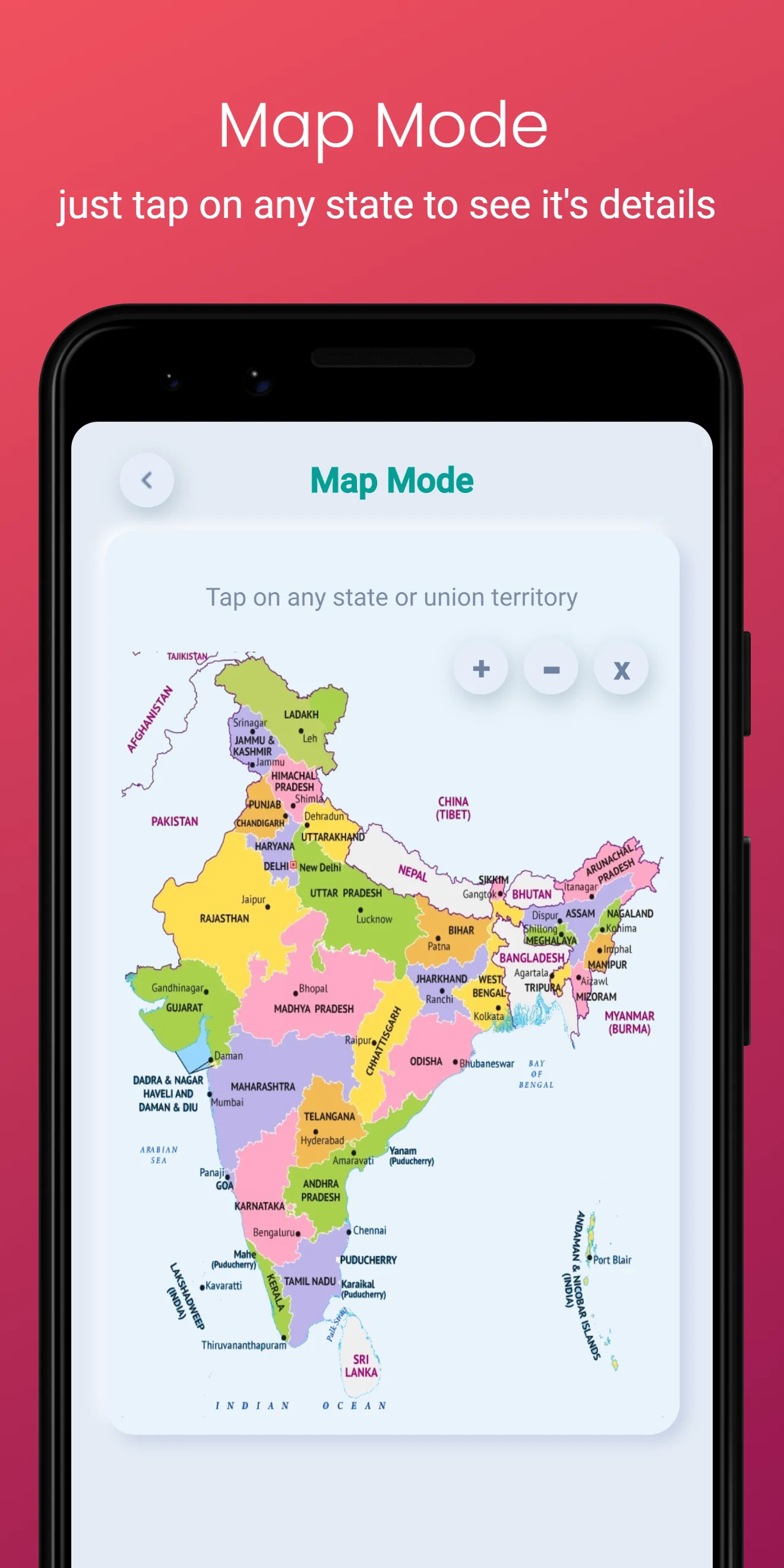
There are 2 modes in which you can read data.
Map mode: shows data for each state separately.
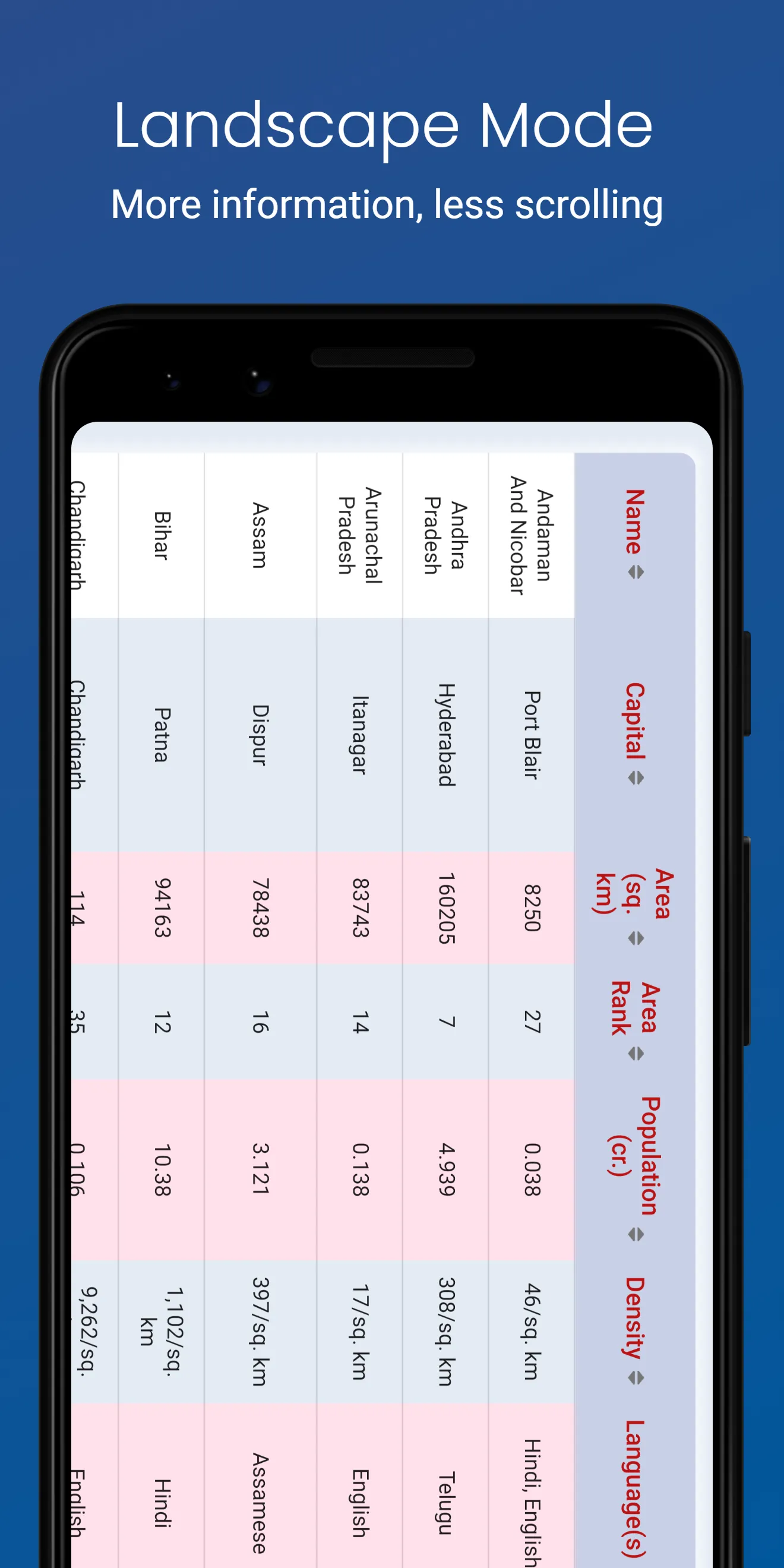
Table mode: shows all data for all states in a single table for easy comparison.
Data shown include:
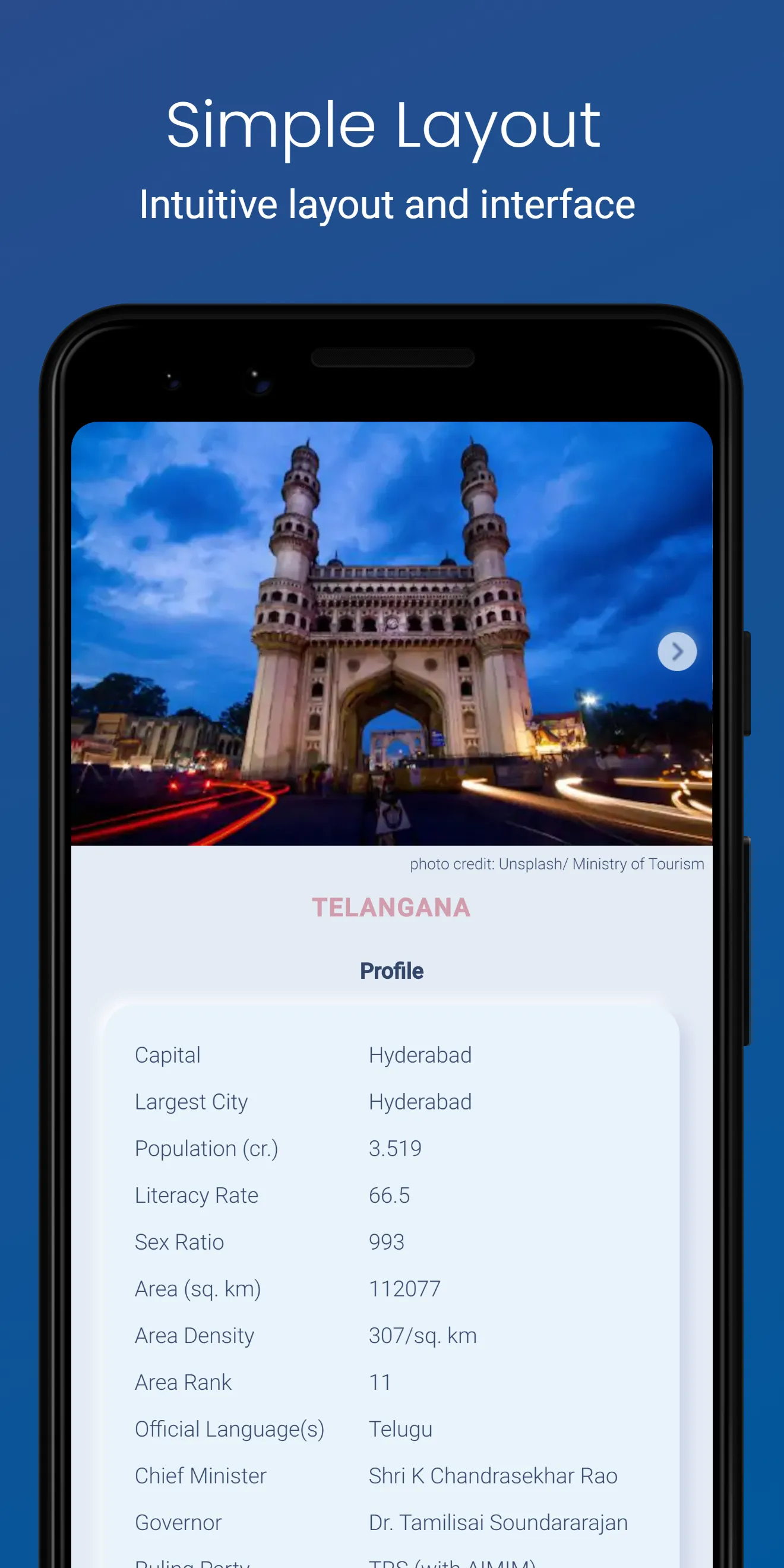
Basic profile: Capital city, Largest City, Total Area , Population, Density, Literacy Rate, Sex Ratio, Official Language(s), Tourist spots
Politics: Chief Minister, Governor, Ruling Party, Lok Sabha Seats
An image gallery showing slideshow of famous places
A short description of the state/ union territory
A link to Wikipedia in case you want to continue reading
Following new data has been added in the latest releases:
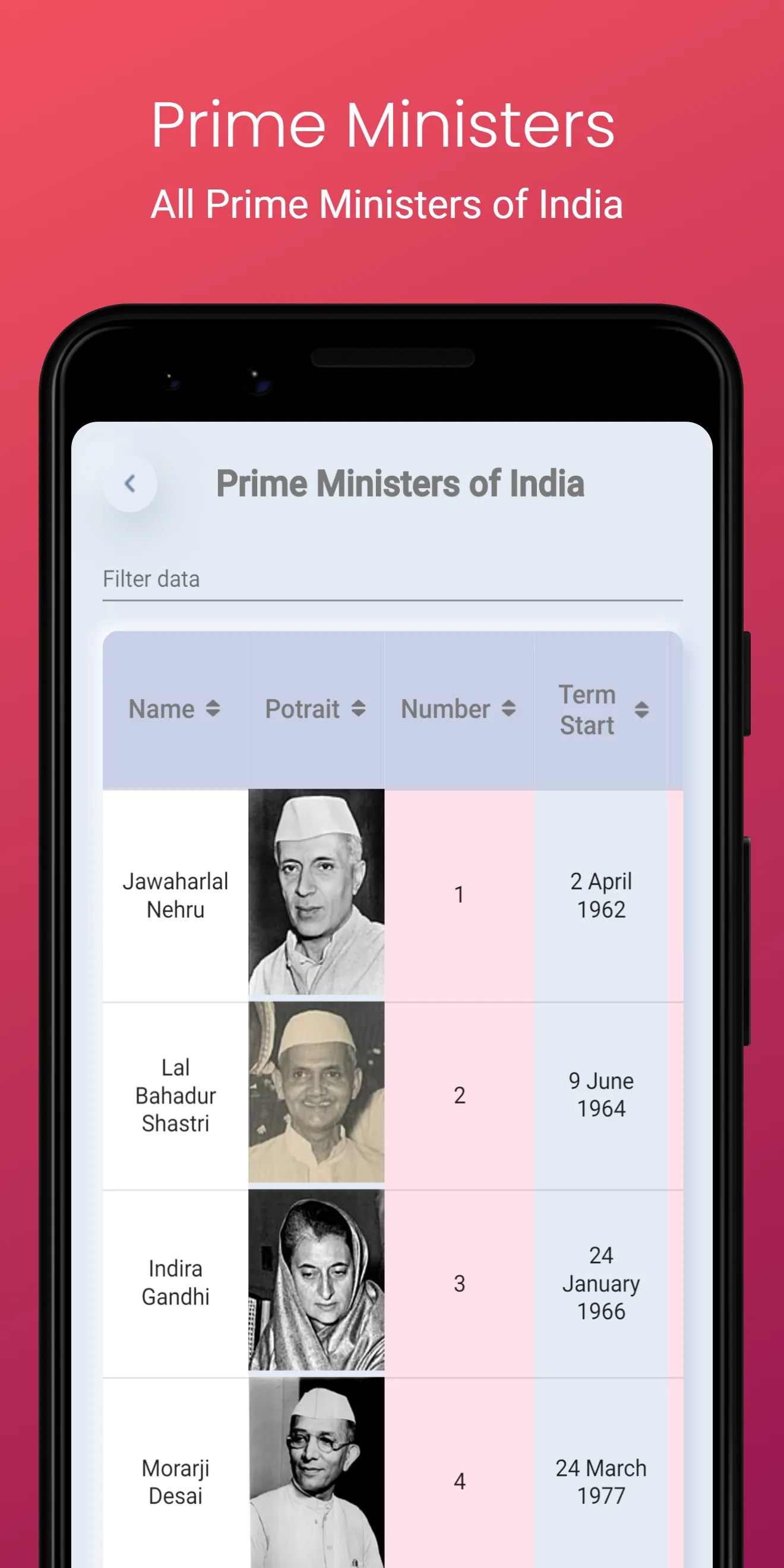
Prime Ministers of India (current and past) - Data includes portrait, tenure start date, tenure end date, total time in office, birth year- death year, constituency, appointed by.
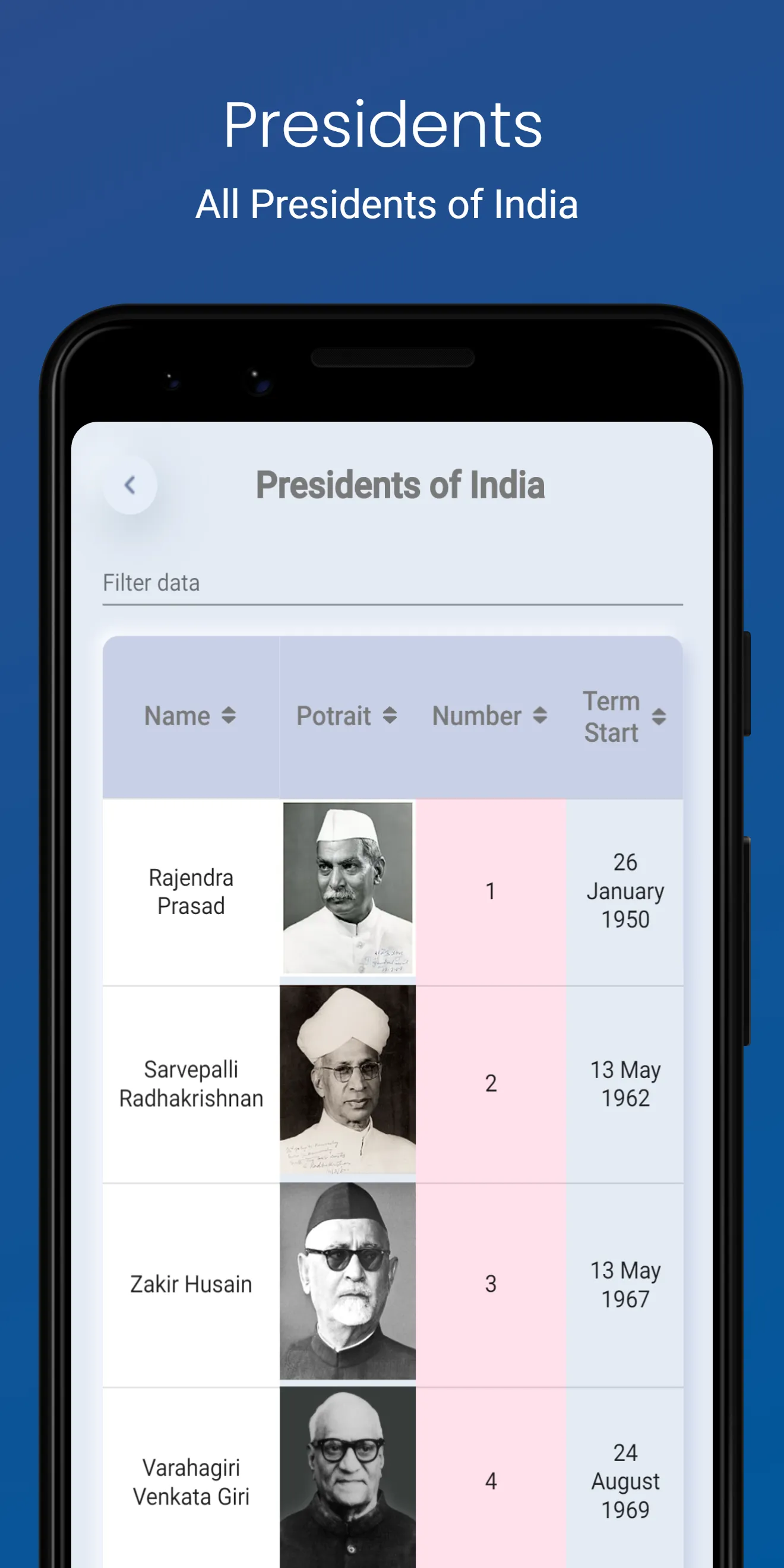
President of India (current and past) - Data includes portrait, tenure start date, tenure end date, total time in office, birth year- death year, previous post, vice president at this time, political affiliation.
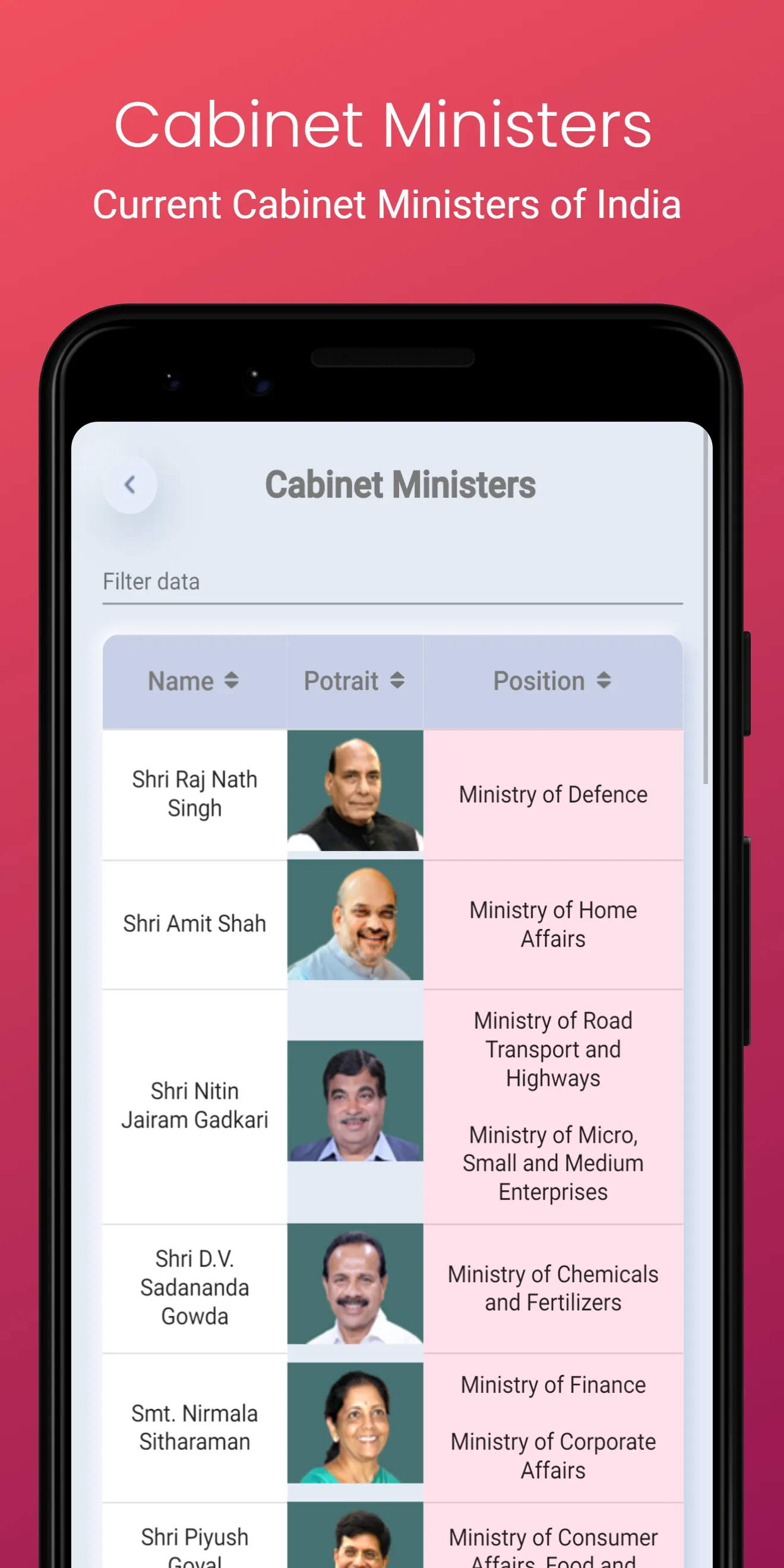
Cabinet Ministers
All Country Data (World data) - Data includes flag, capital, time zone, currency, languages, area, population, calling code, region and demonym.
All these data are presented in table format with support for filtering and sorting.
There are 2 modes in which you can read data.
Map mode: shows data for each state separately.
Table mode: shows all data for all states in a single table for easy comparison.
Data shown include:
Basic profile: Capital city, Largest City, Total Area , Population, Density, Literacy Rate, Sex Ratio, Official Language(s), Tourist spots
Politics: Chief Minister, Governor, Ruling Party, Lok Sabha Seats
An image gallery showing slideshow of famous places
A short description of the state/ union territory
A link to Wikipedia in case you want to continue reading
Following new data has been added in the latest releases:
Prime Ministers of India (current and past) - Data includes portrait, tenure start date, tenure end date, total time in office, birth year- death year, constituency, appointed by.
President of India (current and past) - Data includes portrait, tenure start date, tenure end date, total time in office, birth year- death year, previous post, vice president at this time, political affiliation.
Cabinet Ministers
All Country Data (World data) - Data includes flag, capital, time zone, currency, languages, area, population, calling code, region and demonym.
All these data are presented in table format with support for filtering and sorting.


'%3e%3cellipse%20cx='28'%20cy='24'%20rx='24'%20ry='24'%20fill='white'%20fill-opacity='0.9'%20shape-rendering='crispEdges'/%3e%3c/g%3e%3cmask%20id='mask0_142_4888'%20style='mask-type:alpha'%20maskUnits='userSpaceOnUse'%20x='20'%20y='16'%20width='16'%20height='16'%3e%3crect%20x='20'%20y='16'%20width='16'%20height='16'%20fill='%23474747'/%3e%3c/mask%3e%3cg%20mask='url(%23mask0_142_4888)'%3e%3cpath%20d='M25.4759%2024.0931L30.858%2029.3481C31.0411%2029.5268%2031.1296%2029.7353%2031.1235%2029.9737C31.1174%2030.212%2031.0228%2030.4205%2030.8397%2030.5992C30.6567%2030.778%2030.4431%2030.8674%2030.199%2030.8674C29.9549%2030.8674%2029.7413%2030.778%2029.5583%2030.5992L23.9198%2025.1119C23.7734%2024.9689%2023.6635%2024.808%2023.5903%2024.6293C23.5171%2024.4506%2023.4805%2024.2718%2023.4805%2024.0931C23.4805%2023.9143%2023.5171%2023.7356%2023.5903%2023.5569C23.6635%2023.3781%2023.7734%2023.2172%2023.9198%2023.0743L29.5583%2017.569C29.7413%2017.3903%2029.958%2017.3039%2030.2082%2017.3099C30.4583%2017.3158%2030.675%2017.4082%2030.858%2017.5869C31.0411%2017.7656%2031.1326%2017.9742%2031.1326%2018.2125C31.1326%2018.4508%2031.0411%2018.6594%2030.858%2018.8381L25.4759%2024.0931Z'%20fill='%23474747'/%3e%3c/g%3e%3cdefs%3e%3cfilter%20id='filter0_d_142_4888'%20x='0'%20y='0'%20width='56'%20height='56'%20filterUnits='userSpaceOnUse'%20color-interpolation-filters='sRGB'%3e%3cfeFlood%20flood-opacity='0'%20result='BackgroundImageFix'/%3e%3cfeColorMatrix%20in='SourceAlpha'%20type='matrix'%20values='0%200%200%200%200%200%200%200%200%200%200%200%200%200%200%200%200%200%20127%200'%20result='hardAlpha'/%3e%3cfeOffset%20dy='4'/%3e%3cfeGaussianBlur%20stdDeviation='2'/%3e%3cfeComposite%20in2='hardAlpha'%20operator='out'/%3e%3cfeColorMatrix%20type='matrix'%20values='0%200%200%200%200%200%200%200%200%200%200%200%200%200%200%200%200%200%200.25%200'/%3e%3cfeBlend%20mode='normal'%20in2='BackgroundImageFix'%20result='effect1_dropShadow_142_4888'/%3e%3cfeBlend%20mode='normal'%20in='SourceGraphic'%20in2='effect1_dropShadow_142_4888'%20result='shape'/%3e%3c/filter%3e%3c/defs%3e%3c/svg%3e)
'%3e%3cellipse%20cx='28'%20cy='24'%20rx='24'%20ry='24'%20transform='rotate(-180%2028%2024)'%20fill='white'%20fill-opacity='0.9'%20shape-rendering='crispEdges'/%3e%3c/g%3e%3cmask%20id='mask0_142_4982'%20style='mask-type:alpha'%20maskUnits='userSpaceOnUse'%20x='20'%20y='16'%20width='16'%20height='16'%3e%3crect%20x='36'%20y='32'%20width='16'%20height='16'%20transform='rotate(-180%2036%2032)'%20fill='%23474747'/%3e%3c/mask%3e%3cg%20mask='url(%23mask0_142_4982)'%3e%3cpath%20d='M30.5241%2023.9069L25.142%2018.6519C24.9589%2018.4732%2024.8704%2018.2647%2024.8765%2018.0264C24.8826%2017.788%2024.9772%2017.5795%2025.1603%2017.4008C25.3433%2017.222%2025.5569%2017.1326%2025.801%2017.1326C26.0451%2017.1326%2026.2587%2017.222%2026.4417%2017.4008L32.0802%2022.8881C32.2266%2023.0311%2032.3365%2023.192%2032.4097%2023.3707C32.4829%2023.5494%2032.5195%2023.7282%2032.5195%2023.9069C32.5195%2024.0857%2032.4829%2024.2644%2032.4097%2024.4431C32.3365%2024.6219%2032.2266%2024.7828%2032.0802%2024.9257L26.4417%2030.431C26.2587%2030.6097%2026.042%2030.6961%2025.7918%2030.6901C25.5417%2030.6842%2025.325%2030.5918%2025.142%2030.4131C24.9589%2030.2344%2024.8674%2030.0258%2024.8674%2029.7875C24.8674%2029.5492%2024.9589%2029.3406%2025.142%2029.1619L30.5241%2023.9069Z'%20fill='%23474747'/%3e%3c/g%3e%3cdefs%3e%3cfilter%20id='filter0_d_142_4982'%20x='0'%20y='0'%20width='56'%20height='56'%20filterUnits='userSpaceOnUse'%20color-interpolation-filters='sRGB'%3e%3cfeFlood%20flood-opacity='0'%20result='BackgroundImageFix'/%3e%3cfeColorMatrix%20in='SourceAlpha'%20type='matrix'%20values='0%200%200%200%200%200%200%200%200%200%200%200%200%200%200%200%200%200%20127%200'%20result='hardAlpha'/%3e%3cfeOffset%20dy='4'/%3e%3cfeGaussianBlur%20stdDeviation='2'/%3e%3cfeComposite%20in2='hardAlpha'%20operator='out'/%3e%3cfeColorMatrix%20type='matrix'%20values='0%200%200%200%200%200%200%200%200%200%200%200%200%200%200%200%200%200%200.25%200'/%3e%3cfeBlend%20mode='normal'%20in2='BackgroundImageFix'%20result='effect1_dropShadow_142_4982'/%3e%3cfeBlend%20mode='normal'%20in='SourceGraphic'%20in2='effect1_dropShadow_142_4982'%20result='shape'/%3e%3c/filter%3e%3c/defs%3e%3c/svg%3e)
Developer Infomation
Safety starts with understanding how developers collect and share your data. The developer provided this information and may update it over time.

Email :